Primary Geological & Secondary Anthropogenic Deserts
To fully understand the failures of indexing desertification by forcing territorial, cartographical delineations to distil out localised failures, it is necessary to understand deserts — through pedalogical, aeolian, hydrological, ecological, radiative, and social cycles — to distinguish between primary deserts and secondary ones.
The former is a geological deserts, while the latter is an anthropogenic desert. Although they share a state of aridity, despite apparent similarities at first glance and through standard satellite views, their rates and causes of formation as well as their various cycles are vastly different, necessitating different treatments.
Aridity results from mechanisms limiting moisture in overland atmosphere, and four factors contribute to it. Limited rainfall due to atmospheric stability creates the Kalahari and Australian Deserts of the southern hemisphere, and the Sahara, Arabian, and Thar Deserts of the northern. Cold ocean currents causing dryness on some coastlines create deserts such as the Namib and Atacama Deserts, as does continentality — the presence of great distance between the deserts and the oceans — and rain shadows — the occurrence of deserts on lee (downward) side of mountain barriers.
The Gobi, for instance, is an example of continentality. Although it is in the rain shadows of the Himalayas and the Altai mountains, its sheer scale is defined by its distance from the Pacific and Indian Oceans — by the time air masses reach the Mongolian plateau, they have already lost their moisture over Asia’s landmass. On the other hand, Taklamakan is not only the most ‘inland’ desert on Earth, located as far from any ocean as geographically possible and thus suffering from continentality, it is also extremely shadowed, almost entirely ringed by high mountains: Kunlun to the south, Pamir to the west, and Tian Shan to the north. In fact, it is double-walled from the South-side, where it is also in the rain shadow of Himalayas. Moisture-laden air from the Indian Ocean moves north, forced upwards by the Himalayas where the water precipitates out as snow and rain on the southern slopes, leaving the air travelling across the Tibetan Plateau — the world’s highest plateau and a high-altitude desert — where it will reach the Kunlun Mountains at the southern rim of the Tarim Basin in which the Taklamakan Desert sits, where it will be forced upwards once more with what little moisture it has left precipitated out on these mountains.
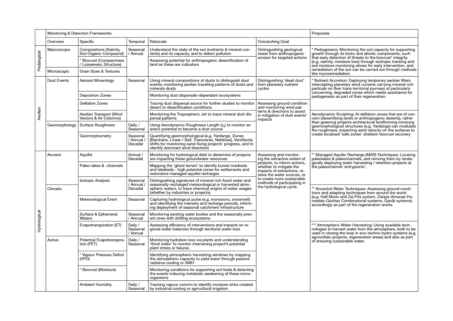
Pedological
Soil erosion forms deserts. As soil loses its fine, carbon- and nutrient-rich fractions and its physical, chemical, and biological properties are altered, such as soil albedo, temperature, evapotranspiration, water-holding capacity, and soil biodiversity. The process of soil particles being displaced by water or wind is itself influenced by topography, determined by slope steepness and length, and soil erodibility, determined by properties such as soil texture, structure, moisture, organic carbon content and more, as well as vegetation cover.
It is possible to understand the landscape of primary deserts in relation to erosional cycles occurring on a geological timescale, taking over million of years to form. A desert high plateau of sand-scoured bedrock sometimes referred to as Hamada deserts are the result of high-energy winds stripping the small particles off these rocky plains. The same wind strips finer soil and sediment from sandy plains or broad depressions largely covered in angular boulders or lag gravels, which, left to settle, form self-stabilising shield protecting finer silt underneath from further erosion; these deserts have different names across different deserts, such as Reg (western Sahara), Serir (eastern Sahara), Gibber Plain (Australia), or Saï (Tarim, central Asia).
Meanwhile, shifting sand deserts act simultaneously as deposition zones of silt and sand carried by wind from other areas, and as sources of these dust drifts themselves. Other than these three main forms of deserts - rocky, stony, and sandy - there are also the salt-crust deserts typical of dry lake beds, otherwise known as Playas or Sabkhas.
While primary deserts formed due to geological events — such as the Gobi and Taklamakan created due to the Cenozoic Uplift of the Tibetan Plateau blocking the monsoons — tend to take millions of years, secondary desert formation is accelerated due to anthropogenic practices. Globally, soil is lost at a rate outpacing that of pedogenesis (soil-forming processes); this is exacerbated in lands bordering deserts by the more extreme conditions naturally found there.
Thus, distinguishing between deserts requires understanding the soil conditions such as the grain size compositions and soil textures, the salinity, the soil biota, the soil compositions itself (to understand nutrients and to detect pollution), the compactness and looseness of the soil, and how they are changing over time.
Aeolian
Closely related to soil erosion is the mobilisation of exposed, loose soil by wind contributing to Sand and Dust Storms (SDS), a common occurrence in arid and semi-arid areas. Among these dust emissions are the further travelling ones wherein fine dust particles, lifted several kilometres high into the atmosphere, are transported by strong winds across oceans and continents.
About 75% of global dust emissions arise from natural sources, a major one being topographic depressions in arid regions, mostly dry lake beds with little vegetation cover. Anthropogenic sources, such as the disturbances to sediment or soil surfaces through actions like removing vegetation cover or destroying biological crusts, constitute the remaining 25%. As highlighted in the WAD’s section on SDS, human-induced hydrological changes drive the demand for water in areas adjacent to natural sources, leading to desiccation of wet or ephemeral water bodies which, combined with prolonged droughts, increase risks of SDS events. This echoes a territorial logic of local populations driving the global crises concerned with the damages on human health, agricultural land, infrastructure, and transport.
This drives projects like the TNSFP, which attempted to ‘stop’ dust storms through combating desertification. Some studies looking at the effect of TNSFP on dust storms use Dust Storm Intensity (DSI) measurements considering frequency, visibility, and duration of dust events, and models like Wind Erosion Prediction System (WEPS). They note that the improvement in vegetation within TNSFP’s region correlates to decreased DSI, concluding therefore that the programme ‘greatly improved the vegetation index and effectively reduced DSI in northern China’.
This view, however, reflects a simplified view of SDS which fails to consider its nuances. For dust interacts with, and affects, the climatic systems in a variety of ways. For instance, it can influence radiative balance of our planet by scattering and absorbing incoming solar radiation indirectly, through changing optical properties of clouds. Travelling dust reaching the troposphere have a planetary impact, too. These passengers of the wind currents carrying elements like phosphorous and iron from the deserts, collecting nitrogen from the atmosphere as they travel, then depositing everything on the oceans and terrestrial ecosystems they cross over. The Saharan dust storms fertilising the Amazon rainforest and the ocean between them is one such well-known seasonal event, also the same culprit for the dusty weather events in much of Europe every spring when they make the journey.
Aside from that, it also forgets the other relationship the winds have to the sands - that deserts themselves are shaped by the winds. Not only do the winds erode alongside water, forming deserts, they are also temporally and spatially present in deserts, whether by carving out yardangs or by shifting the sands over the decades.
It is thus beneficial to distinguish between localised dust events with ‘dead’ dust, stripped of minerals and nutrients and thus providing nothing but negative consequences, and those that are part of this planetary aeolian-dust cycles. Aside from detecting dust dispersion sources and distinguishing dust events, to read a desert also involves reading the traces of winds left behind in the formations.
Hydrological
Aside from wind erosion, water erosion creates deserts too, although such events are rarer in the arid and semi-arid regions. While deserts in these areas are defined by the scarcity of moisture, water nonetheless reaches them in various ways. This can be fog, seasonal events such as snowmelt or monsoons, or underground sources in the form of aquifers. Understanding the different hydrological relationships deserts can have creates a nuanced understanding of how to work with the hydrology of the region, which in turn inform the approach.
Moving beyond the binary of wet and dry requires participating in the hydrology instead of simply consuming water. This brings forth two separate proposals.
The first draws lessons from successful projects in other arid and semi-arid areas to distill their principals, as well as technologies involved and their functioning principles. This looks at the Zaï Pits and Half-Moon systems deployed in Sahel areas, the combinatorial systems including Qochas and other techniques used in the Andean regions, as well as atmospheric water harvesting, understanding the various water harvesting techniques and their basis; this can inform the way to carry out Managed Aquifer Recharge (MAR) after suitable locations have been scouted out, as well as in ensuring sustainable water supplies for the populations.
The second is to trace not just the moisture in the air, but to understand if it came from plant evapotranspiration, evapotranspiration (from the ground), or is ambient; to map out the atmospheric water and surface-level waters, including ephemeral waters and those in the bio-crust layer, against groundwaters. It will also have to operate on two temporal scales, both typical daily cycles and seasonal events. By monitoring hydrological pulses and therefore identifying the cycle of water through these desert systems, it forces a logic beyond a binary of wet and dry, establishing instead a basis for a metabolic ledger tracking waters with architectural interventions to become part of the ‘eco-hydro-technosystem’ that participates and works with existing cycles, instead of simply draining reserves or diverting other ecosystems’ resources.
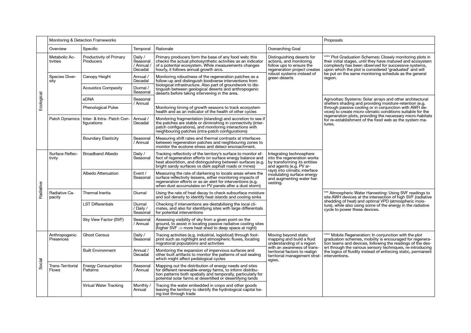
Ecological
Perhaps the most distinguishing factor between primary and secondary deserts is the capacity for life. Primary deserts host their own flora and fauna adapted to conditions present in them. For instance, the great annual temperatures ranging in Gobi and Taklamakan results in plants and animals that have adapted to these cold deserts in unique way through physical adaptations, dormancy, and hibernation, whether animals like the yak and the two-humped Bactrian camel, trees like the saxual, xerophytes like the Artemisia and Stipa, halophytes like the Salsola and Atriplex, or other low-growing plants.
Healthy ecosystems are biodiverse and robust — far from the ‘green deserts’ created in programmes like TNSFP typically focused on cultivating monocultures, which are more manufactured green infrastructure than ecosystems. Thus, while Solar-Induced Fluorescence (SIF) emitted due to photosynthesis by primary producers such as cyanobacteria and plants will be a good indicator for life as ecosystems need primary producers to survive, they cannot be the only indicator used.
Where plenty of vegetation cover exists, diversity in canopy heights indicate a variety of tree and other plant species as they do not mature to the same height, but just as using VIs do not work quite well in desert borders and desert regions, a different way to identify species complexity is necessary. This ranges from surveying DNA samples to understanding species presences, to surveying sound complexities — green deserts, just like secondary deserts, are silent, for they are devoid of much other life than the plant, whether insects and fungus or plants and animals.
Radiative
Soil erosion fundamentally alters a landscape’s radiative cycle, for it alters soil albedo and temperature. As surface albedo increases, more shortwave solar radiation is reflected back into the atmosphere. High-albedo surfaces such as the bright, sandy primary deserts technically reflects more energy, while the lack of vegetative cover creates a loss of vegetative heat sinks. This, combined with the soil’s diminished capacity to retain moisture, creates Land Surface Temperature (LST) spikes. Along desert ecotones, these thermal instabilities can drive further desiccation.
In pursuing renewable energy, solar PV arrays are often placed in ‘empty’ deserts for the easy access to solar energy, where they become part of the radiative cycle.
While these farms potentially create Photovoltaic Heat Island (PVHI) effects, they also show potential to participate in the regeneration of the ecotone, both by acting as artificial shade, and by being a power source for Atmospheric Water Harvesting (AWH) devices.
PV panels can act as a surrogate canopy, shielding the ground to reduce evapotranspiration of the soil, assisting re-establishment of biological soil crusts (biocrusts) and drought-resistant halophytes. By strategically coupling them with AWH devices, moisture lost through evapotranspiration and plant evapotranspiration can be captured, closing the hydrological cycle until the soil has stabilised. This arrangement can potentially capitalise on the PVHI effect, using the thermal energy of the panels to capture moisture. The aggregated water can then be redirected to clear dust accumulation, working alongside self-cleaning PV panels to maintain efficiency of the PV farms without placing further strain on groundwater and other water resources.
In this eco-techno-hydrosystem, energy production ceases being an extractive land- or water-use, acting instead as a metabolic facilitator closing the loop between evaporated groundwater and surface ecology. By integrating the technosphere into the radiative cycle, it can simultaneously power populations in cities far away while modulating the interface between the sun and the soil as a climatic interface, rather than imposing an industrial grid. Thus to manage the recovery of the anthropogenic desert, other than energy output, the monitoring framework also has to keep a metabolic ledger of temperature differentials, heat fluxes, albedo attenuation, and Vapor Pressure Deficits (VPD).
Social
If the primary desert is defined by geological time, the secondary desert is defined by the acceleration of Social Metabolism — the exchange of materials and energy between the biophysical world and human societies. Thus, reading human presences require moving beyond census datasets and institutional mappings correlating population density directly with land degradation; this reductionist logic conveniently blaming the subsistence farmers and pastoralists while masking larger economic pressures driving land exhaustion.
Human presences are not merely environmental stressors, for they can provide traditional knowledges inherent to these landscapes. While programmes like the TNSFP imposes rigid monocultural solutions, creating biological infrastructures ignorant of territorial nuances, local land management techniques operating on sub-pixel scales such as nomadic grazing patterns or seasonal water harvesting follows the rhythms of the cycles in these lands.
These simple, low-impact feedback loops historically maintain the fragile equilibrium of desert ecotones. As resources in drylands are episodic, fixed fencing forces overgrazing while nomadic pastoralism allows the land to recover through mobility. Similarly, water management practices mentioned mentioned previously in the hydrological section and the many others, for instance Qanats (underground tunnels) and Hafirs (earth basins), captures ephemeral water to stabilise the local water table. These practices, sensitive to the rhythms of this zone, provides a resilience that static biological infrastructures displacing populations lack, rendering the landscape brittle.
In the Anthropocene, trans-territorial flows abound. An exhausted desert aquifer is rarely a localised phenomenon; it is likely the result of a trade in virtual waters. This creates a Metabolic Rift — with the desert paying a hydrological and biological debt to sustain urban populations thousands of kilometres away, shipping out its water reserves in the form of livestock, silicon, and ecological spectacles catering to global standards.
Tracking social flows such as virtual water exports and logistics alongside population presences integrates human activities into a metabolic ledger. In this view, the desert’s edge is not just a static line in the sand, but a global node in a metabolic network, thus requiring a monitoring framework accounting for both local knowledge and planetary extractions.
Metabolic Ledgers: Parameters for Reading a Desert
To read the desert to better inform efforts combating desertification requires bridging planetary cycles — geological, aeolian, hydrological, ecological, radiative, and social — with a unified framework of observation. The following parameters distill these complex rhythms into a legible metabolic ledger, shifting away from searching for static boundaries to a close reading of a living zone. This establishes a baseline for the following chapter, which details the mechanisms for monitoring and explores how this act of observation can be transformed from a passive recording into a restorative architectural practice.